 Goal: Restore and protect landscapes
Support the Northwest Florida Sentinel Landscape designation for capacity support to promote conservation and increase recreation access in areas surrounding military installations.
Leverage the Southeast Conservation Blueprint and other complementary data to strengthen funding applications and bring in new funding.
Northwest Florida Sentinel Landscape
The Sentinel Landscapes Partnership is a coalition of federal agencies, state and local governments and nongovernmental organizations that works to strengthen military readiness, sustain agricultural productivity, conserve natural resources and increase access to recreation in areas surrounding military installations. The Partnership coordinates funding and assistance programs to achieve mutual benefits at the landscape scale for national defense, local economies and conservation.
Supporting the development of a Sentinel Landscape in Northwest Florida could provide valuable regional capacity support in protecting critical landscapes for habitat as well as sustaining longleaf pine forests and other agricultural resources.
Eglin Air Force Base is nominating the Florida Panhandle for federal designation as the Northwest Florida Sentinel Landscape. A Sentinel Landscapes designation provides greater access to funding and voluntary federal assistance for projects that conserve watersheds and wildlife habitat, protect agricultural lands, provide community recreation opportunities and support the missions of Northwest Florida’s military installations. The pre-proposal application for designation of the Northwest Florida Sentinel Landscape will be submitted by March 29, 2021. If invited to submit a full proposal, the full proposal will be submitted in August 2021 with three to five Sentinel Landscape designations approved in December.
Additional Resources
Northwest Florida Sentinel Landscape Story Map
Southeast Conservation Blueprint
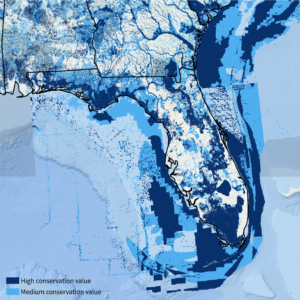
The Southeast Conservation Blueprint is the primary product of the Southeast Conservation Adaptation Strategy (SECAS). The Blueprint is a living, spatial plan that identifies important areas for conservation and restoration across the Southeast and Caribbean. It stitches together smaller subregional plans into one consistent map, incorporating the best available information about key species, ecosystems, and future threats. More than 1,700 people from 500 different organizations have actively participated in its development so far. The Blueprint prioritizes places within Florida Panhandle that offer valuable opportunities for conservation, habitat corridors, and connecting people to nature.
SECAS is a regional conservation initiative working towards a connected network of lands and waters that supports thriving fish and wildlife populations and improved quality of life for people. In addition to the Blueprint, SECAS offers a free support service to people and organizations interested in using the Blueprint and other complementary data to strengthen funding applications, communicate how particular sites or landscapes align with regional conservation strategies, and identify the best places to work together to conserve natural and cultural resources. So far, the Blueprint has helped bring in more than $31 million in conservation funding to protect and restore almost 70,000 acres.