 Goal: Enhance rivers, lakes and bays.
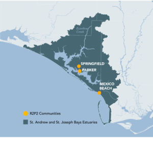
Support the National Estuary Program (NEP) designation for St. Andrew and St. Joseph Bays.
Support Parker, Springfield and Mexico Beach in developing a stormwater management district to provide recreation and flood management.
Support Apalachicola NEP designation.
Leverage the Southeast Conservation Blueprint and other complementary data to strengthen funding applications and bring in new funding.
National Estuary Program
National Estuary Programs (NEPs) are a non-regulatory EPA program that restores waters, habitats and living resources of estuaries of national significance. EPA provides funding and technical assistance to 28 NEPs. Florida has 4 NEPs which include Charlotte Harbor, Indian River Lagoon, Tampa Bay and Sarasota Bay. Bay County, the Nature Conservancy and Florida State University (FSU), Panama City are establishing the St. Andrew/St. Joseph Bays Estuary Program, modeled after the NEP.
St. Andrew and St. Joseph Bays NEP
Bay County and Florida State University are partnering to establish the St. Andrew and St. Joseph Bays Estuary Program. Over the longer term, this program will help provide for the health, enhancement and protection of the Estuary through the development and implementation a plan of action for these valuable resources.
Housed on the FSU Panama City campus, the St. Andrew and St. Joseph Bay Estuary Program will be modeled after the Environmental Protection Agency’s National Estuary Program. It is funded by The Nature Conservancy, Bay County, and Florida State University Panama City, and is facilitated by the Florida State University Consensus Center.
Additional Resources
Stormwater Management District
Stormwater run-off is the biggest and fastest-growing source of water pollution in our communities. A District stormwater management approach focuses on intercepting, slowing, detaining, and infiltrating rainfall rather than allowing the runoff to enter into underground pipes and waterways. A District approach to stormwater management can also allow communities to leverage resources, common goals, project efficiencies, common community benefits and funding opportunities to finance the development of joint green infrastructure projects within the communities to measurably reduce stormwater run-off through proven distributed nature-based solutions. By utilizing green infrastructure best management practices (BMP’s), projects can also provide added flood protection, erosion control, recreational opportunity and stormwater quality enhancement.
Additional Resources
Northwest Florida Watershed Management District
Case Study Example – TNC developed investment models for the Gulf Restoration Council, one focused on the development of regional stormwater wetlands. The case study for stormwater wetlands was based on the City of Milton located in the Pensacola area and could be informative for the ongoing work with the cities of Parker and Mexico Beach. The final report is available here and the appendix with City of Milton case study available here.
NOAA Coastal Flood Exposure Mapper – this online visualization tool supports communities that are assessing their coastal hazard risks and vulnerabilities. The tool creates a collection of user-defined maps that show the people, places, and natural resources exposed to coastal flooding.
EPA’s National Stormwater Calculator is a software application that estimates the annual amount of rainwater and frequency of runoff from a specific site using green infrastructure as low impact development controls. The calculator is designed for use by anyone interested in reducing runoff from a property, including site developers, landscape architects, urban planners, and homeowners.
The National Risk Index is a new, online mapping application from FEMA that identifies communities most at risk to 18 natural hazards. This application visualizes natural hazard risk metrics and includes data about expected annual losses, social vulnerabilities and community resilience.
EPA’s Green Infrastructure in Parks guide is intended to encourage partnerships between park agencies and stormwater agencies aimed at promoting the use of green infrastructure on park lands. Green infrastructure can help to maximize the environmental, economic, and social benefits of parks.
Apalachicola National Estuary Program
Apalachicola National Estuarine Research Reserve (ANERR) was designated in 1979. It is located in Franklin, Gulf and Calhoun counties, within one of the least populated coastal areas of the state. The Apalachicola River basin is only part of the larger Apalachicola-Chattahoochee-Flint River system (ACF), which drains an area covering approximately 19,600 miles, extending into the Blue Ridge Mountains. The Florida portion contains about 2,800 square miles, and the population within Florida’s basin is probably less than 100,000 individuals.
Additional Resources
https://www.apalachicolareserve.com/anerr/
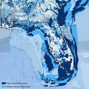
Southeast Conservation Blueprint
The Southeast Conservation Blueprint is the primary product of the Southeast Conservation Adaptation Strategy (SECAS). The Blueprint is a living, spatial plan that identifies important areas for conservation and restoration across the Southeast and Caribbean. It stitches together smaller subregional plans into one consistent map, incorporating the best available information about key species, ecosystems, and future threats. More than 1,700 people from 500 different organizations have actively participated in its development so far. The Blueprint prioritizes places within Florida Panhandle that offer valuable opportunities for conservation, habitat corridors, and connecting people to nature.
SECAS is a regional conservation initiative working towards a connected network of lands and waters that supports thriving fish and wildlife populations and improved quality of life for people. In addition to the Blueprint, SECAS offers a free support service to people and organizations interested in using the Blueprint and other complementary data to strengthen funding applications, communicate how particular sites or landscapes align with regional conservation strategies, and identify the best places to work together to conserve natural and cultural resources. So far, the Blueprint has helped bring in more than $31 million in conservation funding to protect and restore almost 70,000 acres.